
Old French Forts and Guns
on Vung Tau island, Vietnam.
A brief outline of
French Fortification positions in Vung Tau, Vietnam
By Paul Rowe,
Vung Tau,
November 2016.
Vung Tau,
November 2016.
The beautiful, historic island of Vung Tau, Vietnam is littered with colonial era French forts. Some of the French forts, along with their guns, have been destroyed. Others are still used as military establishments by the Vietnam army and navy. Others are being lived in by local people. Some facilities are used as chicken and pig pens. At least one is the home of a hermit monk. Others lie hidden and forgotten under thick tropical jungle.
This article, it is hoped will whet the appetite of fort enthusiasts. It will attempt to give the readers some idea of the volume of forts on this island. By no means is this article comprehensive. No-one at this time really knows how many old French forts and guns were in Vung Tau during colonial times, and no-one knows how many are left standing today. A great project for an enthusiastic fort historian.
I have spent more than ten years wandering across Vung Tau island, and in those travels I have come across many old French forts. I have never set out to intentionally find each and every fort. My interest in the history of this island lies elsewhere. However, with a recently discovered map and my knowledge of Vung Tau I am happy to pass on what I know. I will focus only on fort positions.
Vung Tau island, or Cap Saint Jacques as the French knew it, was ideally positioned to safe guard the mouth of the Saigon River. Whoever controlled the mouth of the river controlled access to Saigon (present day Ho Chi Minh City). The French converted the island to a fortress to resist the English, Spanish and other European colonialist nations from stealing Vietnam.
Most of Vung Tau’s forts and their guns were orientated towards narrowest portion of Gành Rái Bay; a narrow piece of water only 9.5 kilometres wide, between Sao Mai on the extreme northern tip of the west coast and Cần Giờ across the bay. This positioned most forts on the west coast of Vung Tau island. Vung Tau’s two mountains stretch along the west coast so the forts take advantage of the mountains’ natural elevation, protection and camouflage.
Before discussing the positions of the forts within Vung Tau we need to discuss the map. This map is problematic. This map is unsourced, untitled and undated. So we don’t know who charted it, or what time period it is describing. However, it is the best map available at this time. The biggest dilemma that this map presents is, were any more French forts built after this map was commissioned? So again this article is not, and cannot be comprehensive.
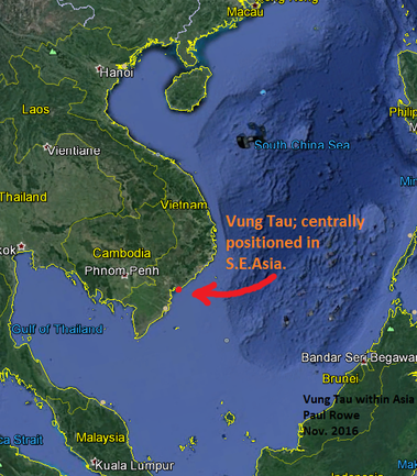
The first map shows Vung Tau and how it is centrally positioned within South East Asia.
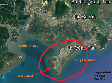
The next map shows the west coast of Vung Tau in relation to Ganh Rai Bay.
And the final map, an old French map, shows the number and locations of French forts in Vung Tau at the time of the map.
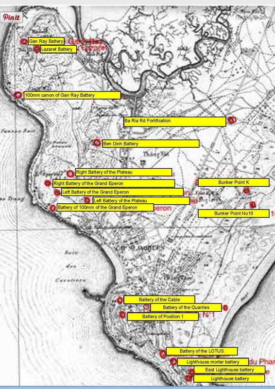
A quick count of the forts positioned on both Big Mountain (north) and Small Mountain (south) shows at the time of this map there were 15 forts stretching the full length of the west coast. This is exactly where French forts would be expected to be located. Fort positioning is all about location, location, location.
On the flats we see Baria Road Fort. This position also makes sense because it guarded the only main road into Cap Saint Jacques.
Further south almost to the eastern coast (today called Back Beach) are two bunker points K and 16. Could these be to protect against an attack from the rear?
The final position, The Battery of the Quarries, seems to be almost on Back Beach. This position seems problematic to me. Vung Tau’s old quarries are in the foothills of the mountains, not on the beach.
As we head further south down the map I also notice that the map is incomplete. The most southern part of Vung Tau, The Point, is missing. At the very end of The Point is a tiny bluff which has French military buildings on it. Nearby Old Woman Island also has at least one casemate.
Again I apologize for using a flawed map, but I hope this brief article has whetted some appetites of fort historians about an exotic, tropical island littered with old French forts and guns. And to tempt you even more, Vung Tau has the only cannons from Indochina War 1 remaining in all of Asia.
VIETNAM HISTORY and CULTURE
and other good stuff.
Posted by Paul Rowe 11/2016, Vung Tau Island, Vietnam.
and other good stuff.
Posted by Paul Rowe 11/2016, Vung Tau Island, Vietnam.
