
The Mystery of the
Missing Baria Citadel
Another Paul Rowe History Mystery
This History Mystery started 07/01/2015 by Paul Rowe, Vung Tau, Vietnam.
I was reading the Viet Nam News at my favourite breakfast and coffee shop and I noticed a couple of lines.
Under the daily column Today in History was this;
1862 The French attack the Ba Ria citadel on Viet Nam's southern coast.
Under the daily column Today in History was this;
1862 The French attack the Ba Ria citadel on Viet Nam's southern coast.
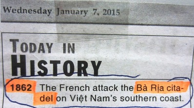
Wednesday 7th January, 2015. This article starts the mystery.
A citadel in Ba Ria! How strange.I had never heard of a citadel in Ba Ria.
Why would Ba Ria have had a citadel? Where was it?
It is only very recently that I had started to have any interest in the town of Ba Ria at all. Up until six months ago Ba Ria was just a largish town 25 minutes north of Vung Tau. A nice place to have Sunday lunch, and that was about it.
Why would Ba Ria have had a citadel? Where was it?
It is only very recently that I had started to have any interest in the town of Ba Ria at all. Up until six months ago Ba Ria was just a largish town 25 minutes north of Vung Tau. A nice place to have Sunday lunch, and that was about it.
Where is Ba ria?
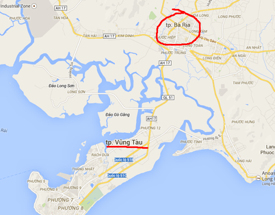
The town of Baria is just north of Vung Tau island.
I know that Baria, and for that matter, all of Baria-Vung Tau Province, oozes history from Indo-China Wars One and Two. It is only very recently that I am starting to appreciate the amount of pre-French history in Baria and its surrounds.
I want to find out;
In the past I have discovered (re-discovered) missing places. For example, the lost Last Tiger Shrine of Vung Tau. That took three years to find, and it started as a rumour. I then uncovered the origins of the pub myth about SAS troops, abseiling from a helicopter to assassinate a French plantation owner.
If I have successfully solved history mysteries which started as rumours and myths, then this should be considerably easier; this mystery starts as a published newspaper article.
I want to find out;
- where the Ba Ria citadel was?,
- why did Ba Ria need a citadel? and
- what part it played in the local history?
In the past I have discovered (re-discovered) missing places. For example, the lost Last Tiger Shrine of Vung Tau. That took three years to find, and it started as a rumour. I then uncovered the origins of the pub myth about SAS troops, abseiling from a helicopter to assassinate a French plantation owner.
If I have successfully solved history mysteries which started as rumours and myths, then this should be considerably easier; this mystery starts as a published newspaper article.
FINDING THE MISSING CITADEL OF BA RIA, VIET NAM.
What am I looking for? A citadel.
According to Merriam-Webster.com:
"cit·a·del noun \ˈsi-tə-dəl, -ˌdel\: a castle or fort that in past times was used to protect the people of a city if the city was attacked.
Full Definition of CITADEL
1: a fortress that commands a city
2: stronghold <the nation's citadel of health research — Constance Holden> <a citadel of higher education>.
Origin of CITADEL
Middle French citadelle, from Old Italian cittadella, diminutive of cittade city, from Medieval Latin civitat-, civitas — city.
First Known Use
1562
Related to CITADEL
Bastion, castle, fort, fastness, fortification, fortress,hold, redoubt, stronghold[+]more
Other Military Terms
bivouac, logistics, petard, salient, sally, supernumerary, tactical."
So I am looking for something old. A substantial sized fort or a castle that is part of a city. Something big. Something military.
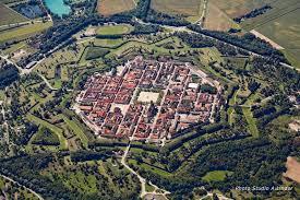
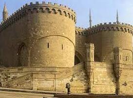
Examples of Citadels
Citadels come in many shapes.
The citadel on the left is La Citadelle de Saint Martin de Re. The other, the Citadelle de Mont Louise
The citadel on the left is La Citadelle de Saint Martin de Re. The other, the Citadelle de Mont Louise
Nguyen citadels and French forts of Vietnam
|
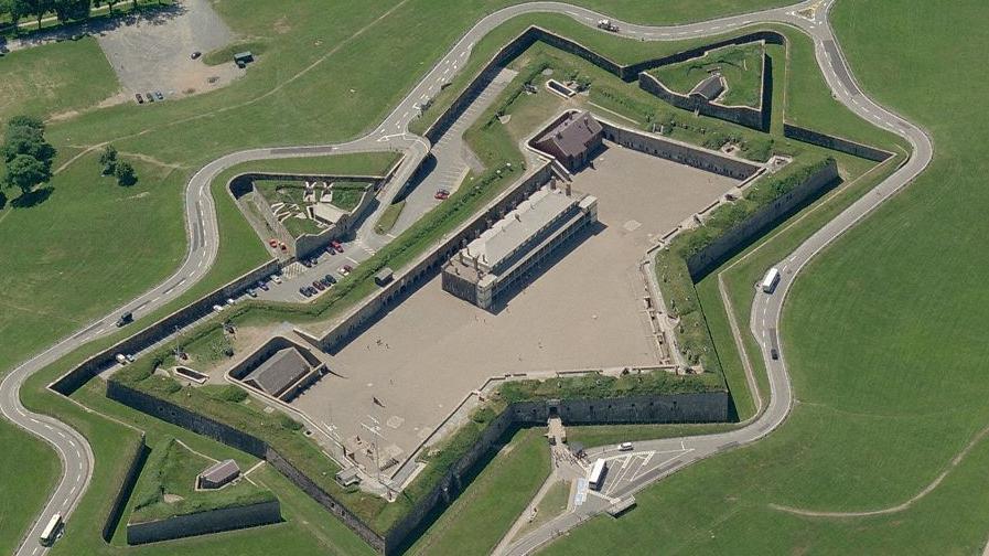
Nguyen citadels and French forts of Vietnam
|
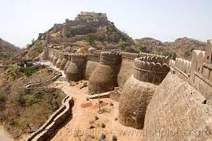
The above citadels are star shaped with a lot of earthworks used for defences, while the two citadels below look like stone castles.
Nguyen citadels and French forts of Vietnam.
|
Nguyen citadels and French forts of Vietnam
|
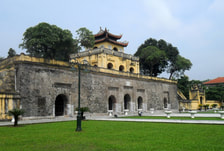
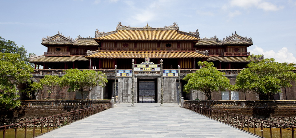
Citadels in Viet nam
Viet Nam's two most famous citadels:
The citadel on the left is found in Ha Noi.
The citadel on the right is the royal Hue citadel.
At this point I suspect there are many more citadels in Viet Nam.
The citadel on the left is found in Ha Noi.
The citadel on the right is the royal Hue citadel.
At this point I suspect there are many more citadels in Viet Nam.
Nguyen citadels and French forts of Vietnam.
|
Nguyen citadels and French forts of Vietnam
|
What I already know about one citadel in Viet Nam
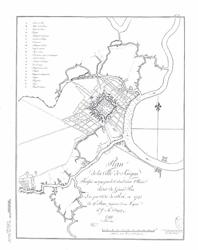
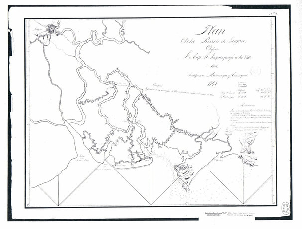
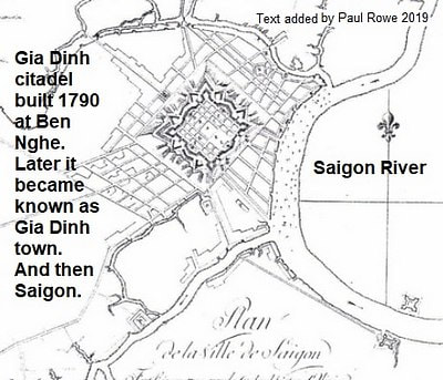
A couple of years ago I was in Paris snooping through the Bibliothèque Nationale de France and came across these two maps. They are dated 1791 and 1799; before the French colonial era. However, the maps are French. The top map shows the citadel in old Saigon. The lower map shows Saigon in relation to old Vung Tau. Both maps are surprisingly accurate. The other surprise is that even though the date 1791 is pre-French, the citadel was designed and built by a French man. The French did not officially start colonizing what is now Viet Nam until 1858ish.
Did this Frenchman make other citadels in Vietnam? Who did he make it for?
I do know that the Sai Gon citadel (Gia Dinh Citadel) (Turtle Citadel) was destroyed in 1835 as a result of a former Viceroy's son declaring himself a king in 1833 and ruling from the massive citadel. The citadel was destroyed by Emperor Minh Mang, the son of the same person who built it - Emperor Gia Long.
A smaller citadel was built to replace it; the Pheonix Citadel. Later, it also was referred to as the Gia Dinh Citadel. The citadel guarded Gia Dinh Prefecture, that is why both citadels inherited the common name.
Nguyen citadels and French forts of Vietnam
This 1799 map (above) very clearly shows the old Sai Gon citadel. Today, roads are positioned because of where the citadel used to be. It was huge! It is interesting that the name 'Saigon' is used on the map. It had another name back then, Gia Dinh.
Nguyen citadels and French forts of Vietnam.
The accuracy of this map is amazing. I superimposed a current Google Earth map over this map, and the distance from Saigon to Vung Tau was exact! The topography of mountain peaks is also stunning. The survey would have been done from a boat (tall ship) going from Vung Tau to Saigon. No GPS!
Citadel versus fort
In the Webster's dictionary a citadel and fort are the same thing. In the real world though, are they the same? We have about sixteen French forts in Vung Tau, and not one of them is as grand as the citadels in the above photos or old maps.
This warrants more research.
This warrants more research.
Nguyen Dynasty forts
The Nguyen emperors had many forts. Could they also be called called citadels?
An incomplete list of Nguyen Dynasty forts (a work in progress):
An incomplete list of Nguyen Dynasty forts (a work in progress):
- Vung Tau. On Big Mountain (Nui Lon). At the present site of The White Palace (Bach Dinh). Circular. You can still today, see the original Nguyen Dynasty fort's stone foundation.
- Along the Sai Gon River.
- Just before Sai Gon either side of the river. Fort South and Fort North.
- Tran Duong That Bao, seven sea defence fortresses (one of them Don Hai), built by King Thieu Tri (Nguyen Dynasty, 1840-47).
Citadel Options
The citadel in Baria that the French attacked in 1868 could have been a Nguyen Dynasty citadel;
1. of non - French design, or
2. of a French design.
The first option seems reasonable because 1868 is correctly positioned during the Nguyen Dynasty.
The second option is a stab in the dark. Did the same Emperor, who commissioned the French naval architect to build the Saigon citadel, also order another citadel for Baria?
QUESTION: When was the Baria citadel built? Answer: anyone?
Nguyen Dynasty citadels and forts.
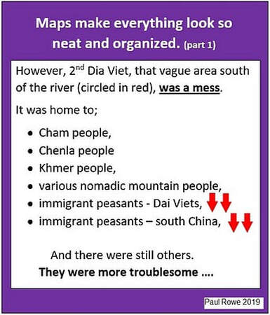
The Nguyen Dynasty spanned 1788 to 1945. In fact, it was Lord Nguyen Anh, the first Nguyen emperor, who was given credit with being the first emperor to successfully unite the new portion (of what is now Vietnam) to the old, original portion (of what is now Vietnam). The ‘new’ segment had recently been acquired from the Cham, the Chenla. the Khemer and various mountain peoples. The transition to a united Vietnam was not swift or smooth; it involved incessantly warring war lords, peasant rebellions, some power seeking Jesuit priests and collusion between royal families of Vietnam and Europe. In short; it was not short, but it was violent and bloody. I suspect that this era will be mentioned again in this mystery.
Any emperor would have made forts across his kingdom to guard against resistance to his reign. So we can expect that Vietnam had many Nguyen Dynasty citadels, forts and army/navy bases by 1862.
|
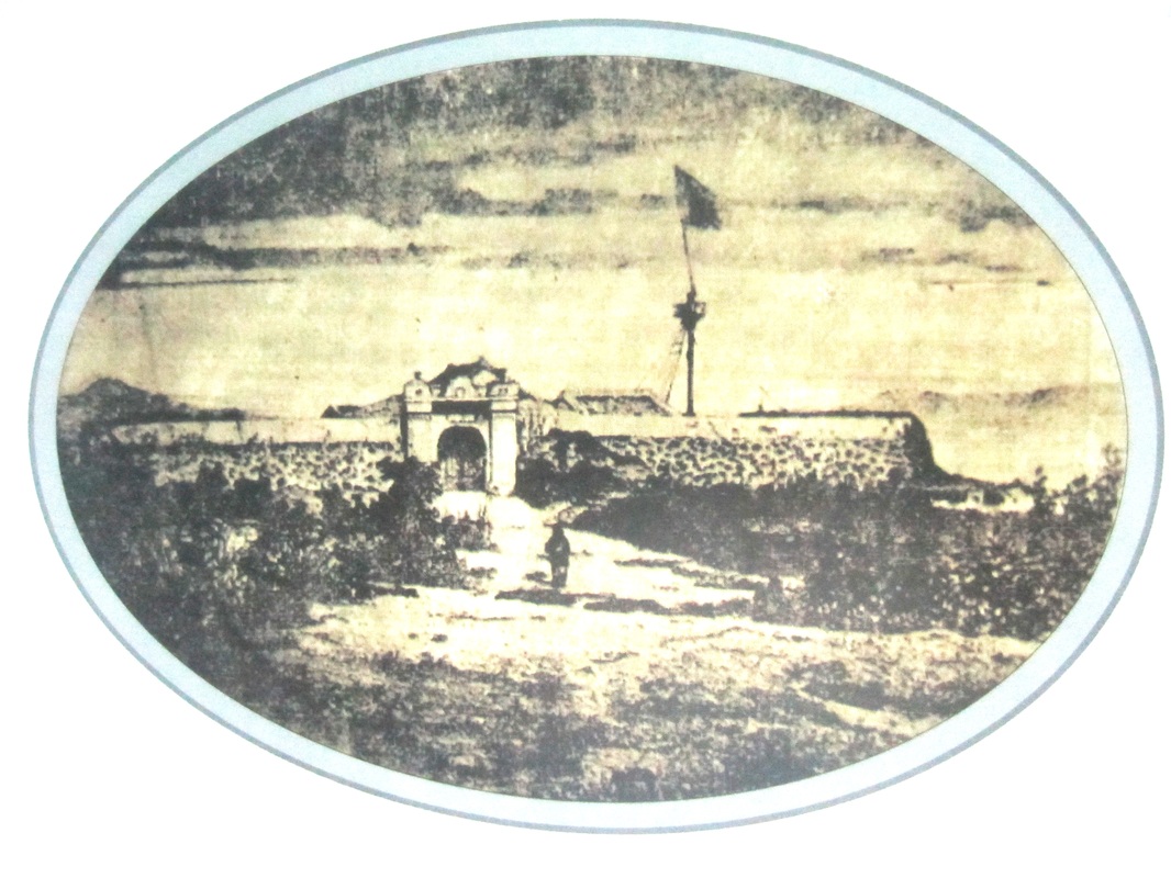
The very first photograph ever-taken of anywhere in Vietnam was of a photograph of a Nguyen Dynasty fortress; the 'View of Don Hai fortress of Cochinchina', Da Nang (Da Nang: Once Upon a Time, 2012). This 1845 sepia photograph, taken by Frenchman Jules Itier recorded three things;
|
Nguyen citadels and French forts of Vietnam.
|
The colonization formula
|
Colonization of Asia, Africa and most other places by Westerners followed a set formula.
France's take over of Vietnam was no different. French Jesuit priests kicked out of Japan and southern China, for trouble making, washed up on the shores near Da Nang as early as 1610. Scores of Catholic priests arrived from France. Many had their ship-fares paid for by businesses in France. The priests often were business agents in Vietnam for the French companies who sponsored them. |
from 'Sai Gon Cho Lon' by Nguyen Duc Hiep.
|
Once these companies started to realise a profit, traders were sent out to replace the priests. France knew Vietnam was profitable by intelligence returned to France by the priests and traders. It was easy for the military to enter on the pretense of helping missionaries or traders in trouble.
So in regards to the above photograph, French priests had been in this area for 235 years prior to this photo being taken of the fortress. The French photographer was part of a Ministry of Commerce and Finance delegation sent from France to China. This photograph would have found its way back to Paris. Thirteen years years later it was this very fortress that was attacked by the French when they attached Da Nang, under the pretense of rescuing some priests. The French knew the colonization formula and followed it to the letter.
So in regards to the above photograph, French priests had been in this area for 235 years prior to this photo being taken of the fortress. The French photographer was part of a Ministry of Commerce and Finance delegation sent from France to China. This photograph would have found its way back to Paris. Thirteen years years later it was this very fortress that was attacked by the French when they attached Da Nang, under the pretense of rescuing some priests. The French knew the colonization formula and followed it to the letter.
|
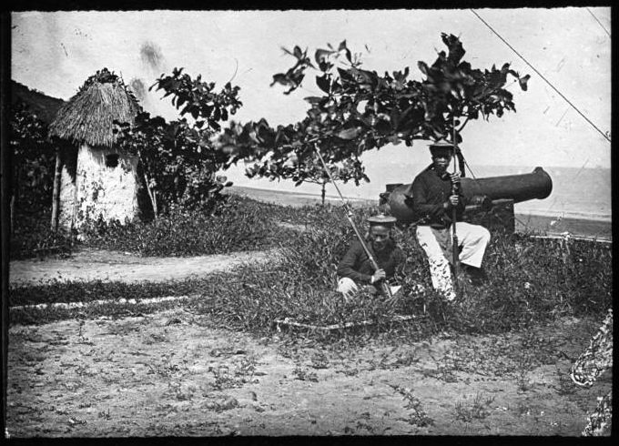
Title : Cochinchine. Baie des Cocotiers du cap S[aint]-Jacques : tirailleurs annamites, mer de Chine / [mission]
English [in other words, today's Front Beach, Vung Tau] [Title: Cochin China. Coconut Bay, Cap Saint -Jacques : Annamite sharpshooters , China Sea / [mission] Blanchet ; [ photogr. reprod . by ] Molteni [presented by] Blanchet conference Author : Blanchet, Fernand (18 .. - 1902 ? ) . Author of the conference. Head of the Mission . Photographer of the work reproduced. Author : Molteni . Photographer] Date of publication : 1888 Subject : Soldats -- Viet-Nam Search all documents with this subject Subject : Vũng Tàu Search all documents with this subject Subject : Cochinchine Source gallica.bnf.fr/ Bibliotheque Nationale de France. |
Nguyen citadels and French forts of Vietnam.
|
Nguyen citadels and French forts of Vietnam.
From Jason on the 3 March 2015.
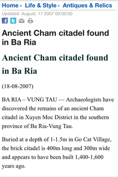
Obviously this is not the 1862 citadel we are investigating, but it adds fuel to the fire that Baria town was powerful some time ago. That power could come from the importance of Baria in Cham times.
The more recent Baria would need to be powerful to warrant a citadel.
Obviously this is not the 1862 citadel we are investigating, but it adds fuel to the fire that Baria town was powerful some time ago. That power could come from the importance of Baria in Cham times.
The more recent Baria would need to be powerful to warrant a citadel.
The last of the Champa land was ceded to Vietnam as recently as 1832.
What is the difference between
Answer = Cham are the people of the Champa Kingdom. 192-1832AD.
What is the difference between
- Cham and
- Champa?
Answer = Cham are the people of the Champa Kingdom. 192-1832AD.
The following article in today's Viet Nam News (6 mar. 2015) is about a citadel just out of Ha Noi; it may provide clues to our missing citadel.
CLICK photo to read more ...
CLICK photo to read more ...
This article could give leads to the missing Baria citadel.

Nguyen citadels and French forts of Vietnam.
A good 20 years BEFORE the Baria Citadel was taken by the French, the Ha Noi Citadel fell to the French.
... Up-date to this History Mystery ... Up-date to this History Mystery ... Up-date to this
Three years after the search for the
MISSING CITADEL started (Jan, 2015),
I now have a position for it (Feb. 2018).
MISSING CITADEL started (Jan, 2015),
I now have a position for it (Feb. 2018).
You would be amazed at the amount of email, and face-to-face response I have had to this particular History Mystery.
The amount of war veterans who said they had seen it during their tour of Indochina War 2. All of them gave me abundant directions to, and descriptions of, the French fort in Baria.
It turned out, that in fact, there were many French forts in and around Baria.
There is also the ruins of a Champa fort or citadel.
It turns out that most of these reports, were about other interesting places, and not about the place I was looking for. Thank you very much for your contributions. All your suggestions were looked into and logged for further reference.
All the reports of forts add to the the notion that Ba Ria at one time was very important.
I had almost given up on finding anything new on this subject until I gain access to Archive 2 in Ho Chi Minh City.
But then I was contacted by Glen, via a contact form on this website. He had found an old auto club map from the French era which showed a citadel in Baria.
It was great to re confirm that the citadel really did exist!
However, auto club maps are often out-of-proportion schematics, more interested in showing hotels and gas stations than historic sites. So instinctively I didn't trust its accuracy.
Nguyen citadels and French forts of Vietnam.
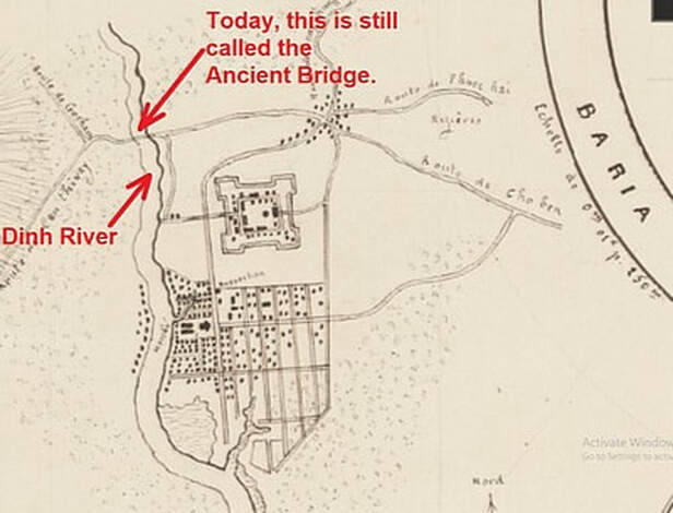
Well done Glen! This auto club map gives up a wealth of knowledge about the citadel.
The Baria Citadel was;
The Baria Citadel was;
- connected to Song Dinh (the Dinh River). A small river which flows through Baria.
- just north of the Vung Tau to HCMC road.
- was a French designed fort (Vauban style). Big find!
Let's re-look at the three questions we are trying to answer via this History Mystery.
- where was the Ba Ria citadel?
- why did Ba Ria need a citadel? and
- what part did it play in the local history?
... Up-date to this History Mystery ... Up-date to this History Mystery ... Up-date to this
And then I was hit with a barrage of information about the missing citadel in Ba Ria.
I have been emailing with An Pham for a couple of years now. He is a university student studying engineering. His hobby is military history. He was the first to supply a photo of the ruins. It is an early aerial photograph from a French magazine of journal. The south bastion is pointed to in the right hand photo. So more proof it actually existed. But a little difficult to relate it to any known points. But it is a start. Thank you An.
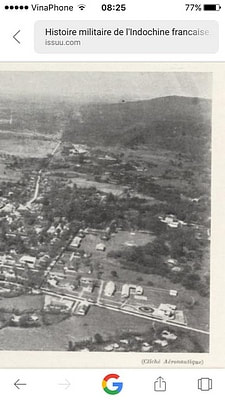
The French military's aerial photograph of the ruins of the south bastion.
|
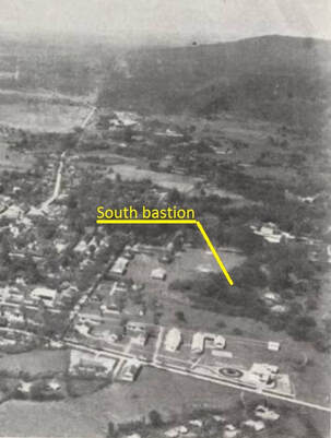
From An Pham. Thanks!
|
I then had an interesting email, not about the citadel per say, but a reminder that the citadel was one small piece in a bigger picture that was being played out across the full length of what is now Vietnam. [I will elaborate on this later].
Comment
"My name is Nhan. I live in Xuyen Moc District, Baria - Vung Tau. The information interests me a great deal. I have never heard of a citadel in Baria, which is now called a city. I just know that Baria is where the first Vietnamese migrants settled as early as in early 1600's, when the territory still belonged to the kingdom of Chenla. Lord Nguyen Phuc Nguyen gained a lot of favor from Chenla by giving his daughter to marry a Chenla king, when the territory still belonged to the kingdom of Chenla."
Thank you for this Nhan. In the early days, Baria was probably called Kas Krobie. It later became Mô Xoài, and then Baria. This seems this area has always been important.
And then came a couple of very useful maps arrived from Pierre Etcheto who lives in France.
Comment
"Dear Mr Paul, 2 maps have just been put online by the french national library (BNF) ...
together they give an fine idea of the city's layout and location. The citadel stood E of the river and N of the city. It was square with 4 corner bastions and 2 gates E and W. No moat is mentioned, but all other citadels had one. Inside, buildings stood along a square circuit street. Overall, a typical Gia Long minor citadel.
Hoping it might help,"
Pierre Etcheto.
We now have actual French sketched maps showing the citadel and its relation to other recognizable places in Baria.
THANK YOU Pierre!
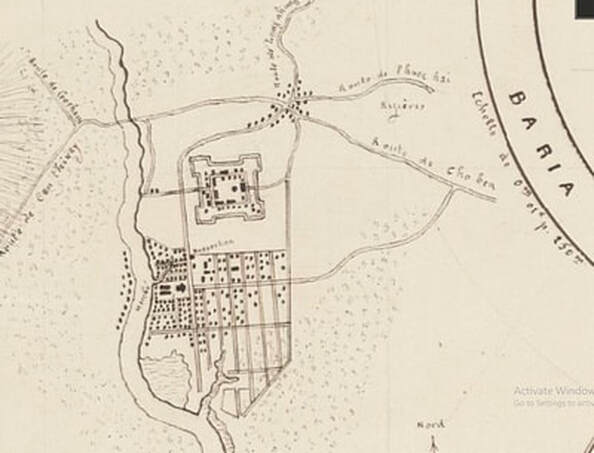
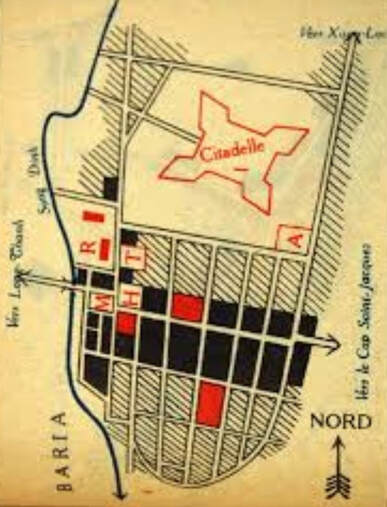
Part of a map - 1874 by Chapntier. Link to map supplied with thanks by Pierre Etcheto.
BNF(réf. GE SH 19 PF 1 QUATER DIV 21 P 5 ). Nguyen citadels and French forts of Vietnam.
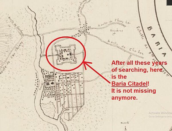
notes in red by Paul Rowe 2019. Nguyen citadels and French forts of Vietnam.
notes in red by Paul Rowe 2019. Nguyen citadels and French forts of Vietnam.
notes in red by Paul Rowe 2019. Nguyen citadels and French forts of Vietnam.
Google Earth maps of Baria, present day. 2019 Paul Rowe
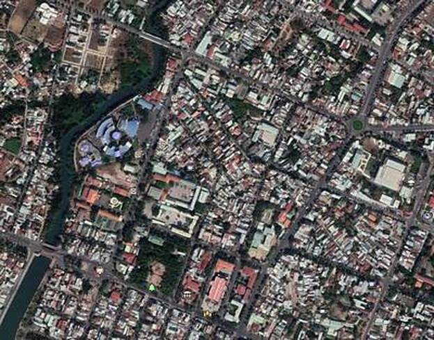
Baria. 9 Sep 2019. Paul Rowe.
Nguyen citadels and French forts of Vietnam.
Baria. 9 Sep 2019. Paul Rowe. Nguyen citadels and French forts of Vietnam.
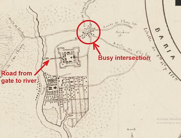
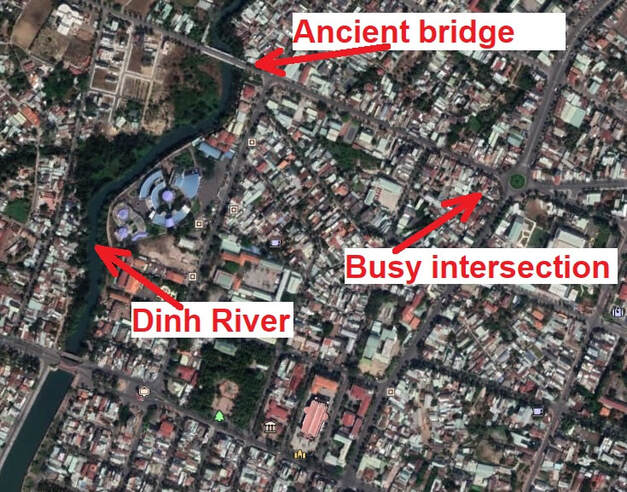
Strong Clues. Baria. 9 Sep 2019. Paul Rowe. Nguyen citadels and French forts of Vietnam.
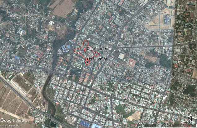
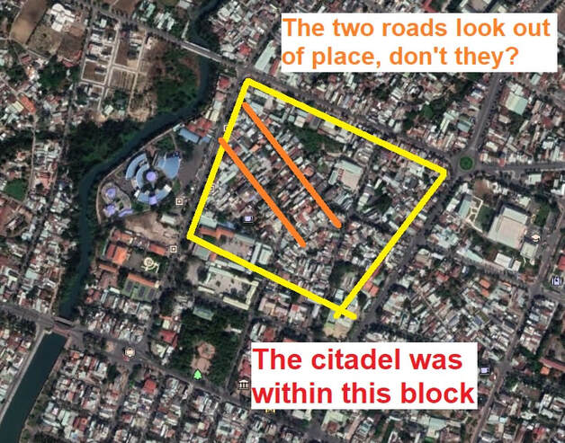
This is where An Pham positions the citadel. Note the two out-of-place roads. They parallel the N.E. wall. Nguyen citadels and French forts of Vietnam.
I have walked this exact area. There is not a brick or stone left of the Baria Citadel.
The area is all concrete, bitumen and houses. There is nothing left of the citadel. I walked the out-of-place roads a few times. They are the only reminders of the citadel now. The road which was once the front gate road, ends only metres from the canal. We will talk more about the canal later. In my book Ancestors and ATMs I talk about Vietnam's history being stolen from them. The Baria citadel is another case of Vietnamese history being erased by the colonizers.
The area is all concrete, bitumen and houses. There is nothing left of the citadel. I walked the out-of-place roads a few times. They are the only reminders of the citadel now. The road which was once the front gate road, ends only metres from the canal. We will talk more about the canal later. In my book Ancestors and ATMs I talk about Vietnam's history being stolen from them. The Baria citadel is another case of Vietnamese history being erased by the colonizers.
... Up-date to this History Mystery ... Up-date to this History Mystery ... Up-date to this
Wed, Sep 11, 8:56 AM (2019)
Just when I thought this History Mystery was winding down, I received some amazing assistance in this case.
I was going through all my emails regarding this case, when I came across an email two years old which I had over looked. A gentleman named Võ Nguyên Phong had simply offered to help, if I needed it. Two years later I replied, "Yes, all help appreciated."
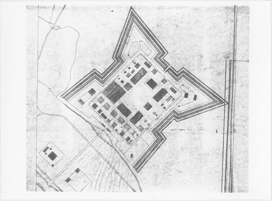
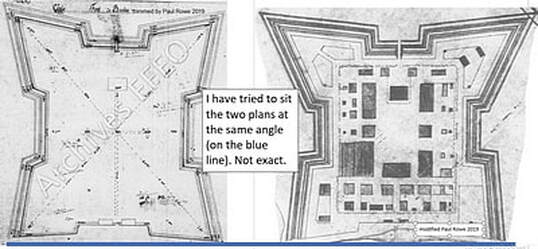
Within days Phong sent two detailed plans of the Baria citadel! And a second photo of the aerial photograph of the southern bastion.Thank you Phong.
Just when I thought this History Mystery was winding down, I received some amazing assistance in this case.
I was going through all my emails regarding this case, when I came across an email two years old which I had over looked. A gentleman named Võ Nguyên Phong had simply offered to help, if I needed it. Two years later I replied, "Yes, all help appreciated."
Within days Phong sent two detailed plans of the Baria citadel! And a second photo of the aerial photograph of the southern bastion.Thank you Phong.
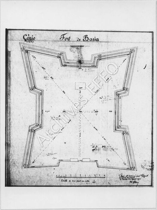
This French drawn plan refers to the Nguyen dynasty military structure as a fort. Could this be a reason why so many Aussie vets were referring to a French fort in Baria?
Drooling yet?
But wait, there's more.
But wait, there's more.
Nguyen citadels and French forts of Vietnam.
A plan of the citadel's internal buildings. Amazing details.
Nguyen citadels and French forts of Vietnam.
The top left and right bastions are different shapes in each plan.
Are we looking at the ground level plan (on the right) and the upper walls (on the left)?
Or, might this be two draughtsmen's different interpretations (errors)?
The one on the left, which I suspect is the copy (the date), shows a t-shaped substructure (the dashed lines). The three short ends of the 't' finish under three buildings, and the long end goes to the canal.
Could it be;
- Sewer system to river? But, I hardly think the toilet block would be the first thing you see when you enter the citadel.
- Water system from the river? The Dinh River is a tidal creek at best. It would be salt water.
- An escape tunnel to the river? In more recent times; when the Aussie soldiers raided the nearby Baria theatre they found a tunnel to the same river. The tunnel in the citadel could have been large enough to float a sampan.
The plan on the right shows the Baria citadel’s internal buildings in detail. Most of the buildings would be military, however, one or more of the larger buildings would have been the all important royal rice granaries.
We have now resolved the first part of this History Mystery;
- where was the Ba Ria citadel?
** We now know WHERE the Baria citadel was located.**
We even know what it looked like.
We even know what it looked like.
We now need to resolve the next two parts of this History Mystery.
2. why did Ba Ria need a citadel? and
3. what part did it play in the local history?
2. why did Ba Ria need a citadel? and
3. what part did it play in the local history?
It turns out that I can answer the next two questions.
When The Mystery of the Missing Baria Citadel started four and a half years ago, I could not have answered the questions. In fact I was surprised that a citadel was even in Baria.
However, for the last three years, I have spent many hours in many museums, libraries, and even Archive 2.
My latest history novel, "Rice and Blood", is about this same era and place. Citadels and royal granaries play a central part in my story line.
The Emperor, his citadels, the rice and the peasants are what created what we now know as Vietnam. That familiar 'S' shaped country. It has only been that shape since 1802. It often comes as a surprise that Vietnam is younger than white Australia.
Nguyen citadels and French forts of Vietnam.
Nguyen citadels and French forts of Vietnam.
Some say that the history of the southern region of what is now Vietnam, is a story of the Nguyens. I do not fully agree with that.
There were Viet rice farmers and traders in this area well before the Nguyens arrived.
In fact, it was the shear volume of the Viet peasants in the area which gave the Nguyens a reason to leave the north and set up their power base in the south.
The majority of the Viet peasants had moved south for the superior rice growing conditions. In the southern regions four rice crops per year were possible. Old Dia Viet (around what we now know as Hanoi) only offered two crops at best.
The Nguyens, who were pro-Emperor at that time, had got themselves into a tricky situation with a rival family, the Trinhs, in old Hanoi. So they moved south to save face, save their lives, and to collect taxes on behalf of the Emperor. They taxed the Viet rice farmers and traders and the tens of 1,000s of Chinese refugees in the area..
After a while the Nguyens decided not to pass on the royal taxes to the Emperor. They commenced their own royal line and started to rule the southern region. At this time this wild region had no official Viet name; the new Dia Viet, or the second Dia Viet, or the great southern land.)
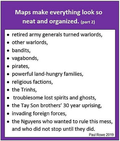
However, at that time the great southern land was in turmoil, and the Nguyens had plenty of opposition from the Emperor, warlords, pirates, bandits and a peasant-driven up-rising.
The Tay Son brothers instigated a 30 year peasant up-rising. This was called the Monsoon War, and was the Nguyens biggest obstacle.
There were Viet rice farmers and traders in this area well before the Nguyens arrived.
In fact, it was the shear volume of the Viet peasants in the area which gave the Nguyens a reason to leave the north and set up their power base in the south.
The majority of the Viet peasants had moved south for the superior rice growing conditions. In the southern regions four rice crops per year were possible. Old Dia Viet (around what we now know as Hanoi) only offered two crops at best.
The Nguyens, who were pro-Emperor at that time, had got themselves into a tricky situation with a rival family, the Trinhs, in old Hanoi. So they moved south to save face, save their lives, and to collect taxes on behalf of the Emperor. They taxed the Viet rice farmers and traders and the tens of 1,000s of Chinese refugees in the area..
After a while the Nguyens decided not to pass on the royal taxes to the Emperor. They commenced their own royal line and started to rule the southern region. At this time this wild region had no official Viet name; the new Dia Viet, or the second Dia Viet, or the great southern land.)
However, at that time the great southern land was in turmoil, and the Nguyens had plenty of opposition from the Emperor, warlords, pirates, bandits and a peasant-driven up-rising.
The Tay Son brothers instigated a 30 year peasant up-rising. This was called the Monsoon War, and was the Nguyens biggest obstacle.
In fact, in 1775 the Nguyens were chased out of their beautiful palace in Hue by the Emperor's army, the Trinh family. The retreated much further south to a small trading port called Ben Nghe (present day HCMC), where they still continued to collect and keep the Emperor's tax money.
Two years later, in 1777 all Nguyen royals, except one youngster, were massacred by the Tay Sons in a successful raid against them at Ben Nghe.
The young Nguyen royal escaped and ran even further south. As soon as the Monsoon winds changed direction the majority of the Tay Son army sailed northward to their base in Qui Nhon, The young Nguyen prince (Nguyễn Phúc Ánh) rallied the help of a southern Mekong warlord and retook Ben Nghe. He was persistent, It took 30 years to eventually triumph over all his adversaries,and seize all land through to Hanoi.

Emperor Gia Long. vietnamthanyeulachong
|
He created the 'S' shaped country, and he called it Vietnam. He changed his name to Emperor Gia Long. China approved of his title and name change.
........ [Remember Nhan (one of the contributors to this case) mentioned someone called Lord Nguyen Phuc Nguyen back in the days of the Chenla people. That was Emperor Gia Long's father.] ......... |
One reason for the Nguyen's tremendous power came from rice. The Nguyens declared a tax on rice.
The Nguyens were fond of taxing, and taxed (over taxed) when ever possible. The main reason for the collapse of the famous international trading port of Hoi An (central Vietnam), was due to the Nguyen's over taxing of foreign maritime traders.
Rice has always been at the heart of Viet's culture, social life, work life and history.
Lord Nguyen Phuc Anh's rice tax made him a fortune. That fortune gave him the power to eventually become Emperor.
His rice tax also struck at the heart of every Vietnamese. It made him unpopular. So unpopular that the rice tax was the excuse and reason for uprisings against him.
The main anti- Nguyen uprising was the Tay Son rebellion. Three brothers from the central village of Tay Son, took advantage of his unpopularity to make a power grab in the name of the oppressed people of the region. It was a 30 year seasonal battle that flowed back and forth between Qui Nhon (central region) and Saigon River area. Because the monsoon winds dictated the movement of the naval fleets, the Tay Son uprising is often referred to as the Monsoon Wars.
The central area lacks arable rice growing land, and therefore at that time, lacked rice. The Tay Son raids would always seize Saigon's rice. They were seizing the Nguyen's taxable rice. To re-gain popularity, Lord Nguyen Phuc Anh built royal granaries inside his forts and citadels.
The citadels;
- protected the rice, so his subjects would not starve due to Tay Son raids,
- gave justification for the rice tax,
- gave justification for building the royal granaries, the forts and the citadels,
- and gave justification for charging the peasants a citadel building tax!
At the beginning of this mystery, I mentioned that I had bought home some very old maps from France which showed a Nguyen dynasty citadel.
Nguyen citadels and French forts of Vietnam.
Let's use the above map to see how important citadels were to the Nguyens.
The above citadel, the Gia Dinh Citadel, was built by Lord Nguyen Phuc Anh. The monsoon Wars had already been dragging out for thirteen, or so, years. Up until the massive Gia Dinh Citadel was built, Lord Nguyen Phuc Anh was not doing well in his military effort to take back his land. He spent a lot of time hiding off the mainland. However with the huge Gia Dinh Citadel he gained a solid capital city. The small trading port of Ben Nghe, became in the important trading port of Gia Dinh on the Saigon River. The citadel was part of the Nguyen war strategy. Because Lord Nguyen Phuc Anh had the protection of the citadel he could collect the rice tax, and further the war effort. For example, at Gia Dinh he constructed the royal ship building yard and cannon foundry. They were world class. He made 100s of galley warships and 1000s of cannons. [Some of these cannons can be seen today in the front gardens of the Royal Palace in Thailand.]
Side note: If you want to find out how incredibly important this citadel was in the overall history of building Vietnam, read my Paul's History Club blog "Where's Saigon?"
.......
I need to emphasize one element to this story. More about - rice.
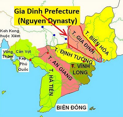
The map below shows the Nguyen Dynasty prefecture of Gia Dinh circled in red.
The above citadel, the Gia Dinh Citadel, was built by Lord Nguyen Phuc Anh. The monsoon Wars had already been dragging out for thirteen, or so, years. Up until the massive Gia Dinh Citadel was built, Lord Nguyen Phuc Anh was not doing well in his military effort to take back his land. He spent a lot of time hiding off the mainland. However with the huge Gia Dinh Citadel he gained a solid capital city. The small trading port of Ben Nghe, became in the important trading port of Gia Dinh on the Saigon River. The citadel was part of the Nguyen war strategy. Because Lord Nguyen Phuc Anh had the protection of the citadel he could collect the rice tax, and further the war effort. For example, at Gia Dinh he constructed the royal ship building yard and cannon foundry. They were world class. He made 100s of galley warships and 1000s of cannons. [Some of these cannons can be seen today in the front gardens of the Royal Palace in Thailand.]
Side note: If you want to find out how incredibly important this citadel was in the overall history of building Vietnam, read my Paul's History Club blog "Where's Saigon?"
.......
I need to emphasize one element to this story. More about - rice.
The map below shows the Nguyen Dynasty prefecture of Gia Dinh circled in red.
Nguyen citadels and French forts of Vietnam.
The lower half of the prefecture contains the one of the world's most fertile rice growing regions.
The red dot shows the town of Gia Dinh (HCMC) with the Gia Dinh Citadel. The citadel was protecting one end of the rice growing strip. The citadel held the royal granary. It protected the rice from the Tay Sons and others. It also allowed the successful taxation of rice to take place. The citadel was crucial to the success of the Nguyens. The rice granary was huge. The royal mandarins, who were the royal tax collectors, were good at their job. When the Gia Dinh Citadel was eventually destroyed, the rice granary was still smoldering three years later. A huge tax surplus!
The Baria Citadel protected the royal rice granary at the coastal end of Gia Dinh prefecture.
After the Gia Dinh Citadel had been built, there was still another twelve years of fighting the Tay Sons. That allowed plenty of time for another citadel (The Baria Citadel) to be built in the resource rich prefecture.
I feel that the second part of our History Mystery has been resolved.
2. why did Ba Ria need a citadel? So the Nguyen Emperor's could 'protect' their royal rice granaries and justify their rice tax.
3. what part did it play in the local history? It maintained the historical importance (power) of the town and ancient region. It also reinforced and protected the economic infra structure in the region.
We have now resolved the history mystery case of
The Missing Baria Citadel;
* where was the Ba Ria citadel?
* why did Ba Ria need a citadel?
* what part did it play in the local history?
The Missing Baria Citadel;
* where was the Ba Ria citadel?
* why did Ba Ria need a citadel?
* what part did it play in the local history?
yee ha!!
A great big thank you to the many people who contributed to the solving of this History Mystery.
Of course, those of us who are interested in history, know that no history mystery is ever REALLY solved. Tomorrow some knew information could be discovered, and .....
Of course, those of us who are interested in history, know that no history mystery is ever REALLY solved. Tomorrow some knew information could be discovered, and .....
ps.
Glen's auto-club map turned out to be surprisingly accurate after all. Thanks again.
pps.
To find out a lot more about how important Baria was in ancient times, check out my recent History Mystery called Where's Saigon. It listed in the menu.
Glen's auto-club map turned out to be surprisingly accurate after all. Thanks again.
pps.
To find out a lot more about how important Baria was in ancient times, check out my recent History Mystery called Where's Saigon. It listed in the menu.
VIETNAM HISTORY and CULTURE
and other good stuff.
Posted by Paul Rowe across 5 years, Vung Tau, Bangkok, HCMC.
and other good stuff.
Posted by Paul Rowe across 5 years, Vung Tau, Bangkok, HCMC.
